On Sunday 14th June 2015 I decided to do some fast packing. I had been keeping an eye on the weather in the areas I would be passing, and it seemed the perfect time to go. My plan was to do roughly 90 miles from Birmingham, I would go down the Birmingham – Worcester Canal past Worcester and follow it further south to meet with the River Severn. I would camp at a camp site here. The next day I would walk to Malvern which is an area of outstanding natural beauty. I would then start the Worcestershire Way Trail heading north to Bewdley where I would then repeat the North Worcestershire Way trail for the second time this week. The idea was to do one big circular from my house back to my house. So that’s the overview.. and this is how it went.
I packed my usual stuff with me, 20L WAA Ultra Bag 1 man hiking tent, spare tshirt, long johns,spare socks, Thermarest XLite inflatable mattress, OMM Raider 1.0 sleeping bag, Sleeping bag liner, Marmot Essence waterproof jacket. For food I packed 2kg of dates (I did eat in some places along the way though) and I carried 1.5 L bottle of water which I finished off and topped up whenever I could. I didn’t bring my Petzl headtorch as I like to just sleep when it gets dark and I had one on mobile if urgent. I also carried a recharging unit which allowed me to recharge my Garmin Fenix 2 for the entire duration and my iphone about 3 times also. Finally a little cash and a card.
I set out from my house in Northfield Birmingham at 10:30am. I walked down to Wast Hills Lane where I joined up with the canal to Worcester. This path is pretty much down hill the entire time. Even though I walked a fair bit I struggled with this section. I think perhaps because I wasn’t used to carrying 8KG of stuff with me while running. Also what made it hard is that the council has started to turn the tow paths into tarmac paths instead which hurts under foot wearing studded Salomon Speedcross 3s. I have such a love hate relationship with these shoes and I have said before that I would throw them away. This time I have. For a country with little long distance TRAIL ONLY routes I find these to be pretty useless in the way of a quality long distance sneaker. Walking on tarmac roads over long distances with heavy weights on your back, with the studs on the bottom pushing into your feet every 180,000 steps or so over 90 miles really hurts. I’m going to opt for HOKA ONE ONE Maximalist trailies next time.
Regardless I really enjoyed this day. It was familiar ground as I have ran this route 6 times now. There was only the small section past Worcester down to the River Severn I wasn’t sure on but I knew from looking at maps it was very straight forward and I could just follow the Severn Way Sign Posts.


I remember seeing this boat shortly after being set on fire by idiots. The owner has been trying to fix t for many months now. To his, and everyone else’s surprise, some bastard had let it lose overnight and it had drifted down the canal well away from anywhere to tie it up. The owner was just leaving as I arrived, he was very upset and I think had given up on it completely as he walked away soaking wet.

In winter I went the wrong way here and it lead to a horrible dumpy looking cul de sac. I took this picture because as the seasons have progressed it looked just beautiful.


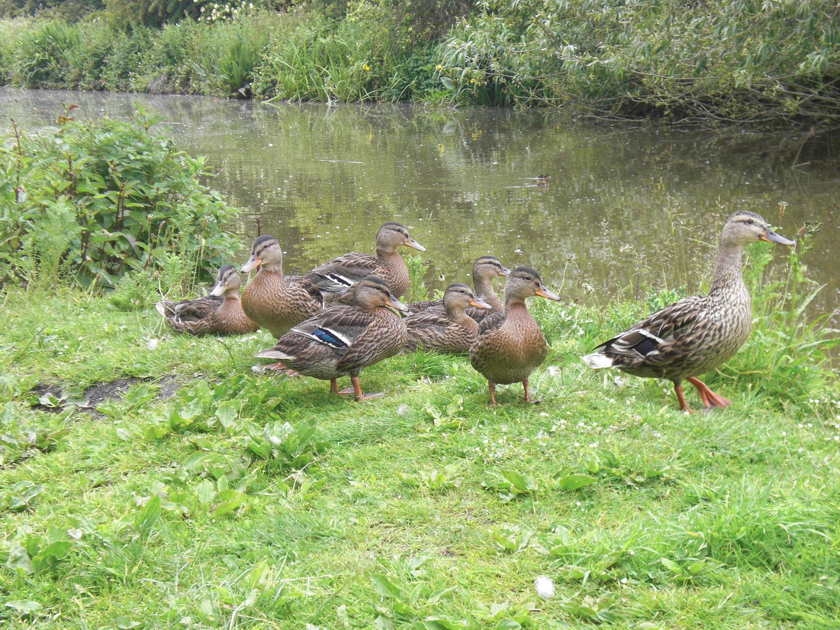 QUACK!
I like bridges for some reason 😉 Hence all the bridge images.


Happy moment. Knowing that I wasn’t too far now from Worcester and then only a few more miles south to the first nights camping spot.


Tried to have a little talk with this swan but he got a bit aggressive with me and tried to bite me lol. Little bugger.


Once I got into Worcester I spotted a Subway and decided to get myself a Salad Sub 😀

It was a nice moment to get the River Severn. I hadn’t been this far down before.

Yay first signs for the Severn Way. Another trail I must do. It’s 150 miles but it’s all downhill so should be a nice one. Right down to Bristol. 🙂

I arrived at The Ketch Campsite early evening. I spoke with the warden there and paid for my hiking tent. This site was right along the river. Lovely location, though you can see why they don’t allow children under 11 here. You can just about see the tips of the Malvern Hills past the River Severn in the distance. That’s where I was heading the next day.
I did about 28 miles on this first day. Throughout the day I found myself running a few miles here and there when I could be bothered and wasn’t on stoned or tarmacked ground. I didn’t see this as a race. Just going how I felt.

It was a hard boring 7.5 mile walk to Malvern Hills. I set off at 5am. I tried to plan a trail route but I wasn’t confident in the trail I had created through an advanced route creator online. I worried a lot of it was closed off completely to public so I opted for an A road which ran right to Malvern.


I sort of did one of those little happy dances when I saw this sign. I knew I’d soon be off the busy A road and onto the quieter hills where I belonged.
When I arrived into Malvern the first thing I did was go to COSTA and buy a Soya Latte. I warmed up with this and chilled for a while before heading back out, to a shop to top up water and then to The Hills.


I wish I’d have been here during the afternoon. I was on the East side of the hills and because the sun rises in the East it made it hard to get a good snap of how amazing this view was. You could just see for absolute miles on end of farm lands and tiny villages. There were even a few hot air balloons.


When I got to the top of the hills I started the Route for Worcester Way which I had saved to my Garmin as a GPX file. I was so upset by this. My Garmin Fenix 2 allows you to set how often it records data. I had set it to record every 2 minutes on UltraTrac rather than every second. The result being up to 50 hours battery life. When I activated the route onto my current session (from day one point 1) it changed the recording frequency to SMART and wouldn’t let me decide how often. The dilemma here was that I would need to not use my phone or music anymore and keep charging my Garmin much more with my recharging unit. The alternative would be to save what I had done so far and start a new one to put the settings back to UltraTrac. As I wasn’t even sure I’d have enough recharges for the duration of my journey I decided to save that session and begin a new one. I decided what I would do instead was select “map” option on the Worcestershire Way and follow that. Sadly when I zoomed in further the line showing the route went off the watch so I couldn’t even see where I was going unless I had it at a 30 mile radius. I realised I would have to rely on way marks for the next 65 miles.
This is clearly something I’m going to have to look into. I loved the idea of Fenix 2 for it’s ability to upload GPX or create routes and have such long battery but it seems the battery wont last that long if you use a predetermined route? Why is this? If you have any alternative suggestions that please do let me know. If this wasn’t a waymarked route and I didn’t have a charged phone I would have never made it as far as I did.


This is looking back to the Malvern Hills I had walked up and across earlier.


I believe this is the River Teme. There’s a little Post office around there called Suckly Post Office. I’m not 100% now on locations sorry. Anyway I remember going in to top up my water and I also bought a few apples. I went outside and sat on the bench to eat them. To my surprise a young guy came up to me and asked if I was Vegan. He had spotted my Vegan Runners top and said he was vegan too. He also mentioned he had seen some of my posts on the Vegan Runners Facebook group. It was really nice to bump into a fellow vegan especially in a place like this population 10. He seemed a really happy person and said how lucky he was to live in such a beautiful place in the world. We wished each other well and on I went. Maybe he might read this post… if so say hello 😀

I stopped at a The Talbot pub in this little village called KnightWick and had two portions of chips and a large lemonade. I piled on the salt to replace my salt loss.

Here is another trail I would like to look up. I hope it is full of geological delights. I have a keen interest in geology 😉


I was getting pretty tired by this point and was considering camping around here. I’m not very good at wild camping. When I was a kid I did it all the time but now as an adult and knowing it’s illegal I never know. Also I don’t know if there’s anyone around in the area. It did seem ideal as a place to camp for the night though.


At about mile 30-32 on day 2 I was just turning to go down a hill in the forest. I spotted the lower half of a guy running. He hadn’t spotted me yet and I made a flash decision to start running. There was no way I was going to slog my way down a steep hill in my VEGAN RUNNERS top that he was running UP! So I got going and he said hey. The funny thing was that even after slogging for so many miles that day I managed to pretty much run the last 8 miles all the way into Bewdley.
About a mile out from Bewdley I ran into some danger. This was the only trail I knew of into the village and it really was a race against the sun at this point. I came across a field with what I thought was cows. They seemed relaxed and I (unknowing how dangerous bulls were at the time) decided to take the trail. As I passed about 5 of the 8 or so bulls they blocked off the was I came in. Which meant I had a longish climb uphill to the exit and had to pass 4 more up the hill in the process. Their attitude changed and they began to group up an run in my direction. I turned to face them and slowly walked backwards. I really wanted to run but I knew that bulls are faster than people and I had already done 38 or 39 miles today! I didn’t know how to react so I faced them but didn’t look into their eyes. I opened my arms and showed them my palms. I firmly but calmly said to them “nooooo, come on now… easy boys, you’re ok, I’m not going to hurt you.”. The lead bull settled back a bit and I thought I might be ok. Then one of the other bulls took lead and they all began to charge at me again. This time he got within 2 or 3 meters of me but I managed to somehow get them to calm again. This happened 5 times in total. I really thought I was going to die. So many people get a blow to the head or their body’s crushed. I got out safely though. I managed to find the exact field on Garmin Connect. I sent an email to the Long Distance Path Association to ask who I contact about this. It is my understanding (I could be wrong) that it is highly illegal for farmers to block public rights of way with dangerous cattle and no warning signs or alternative route signs.
As I got into Bewdley I started to pick up the pace as I headed for the River Severn once more 🙂
I went to The Cooperative to top up my water and buy 600g of Strawberries. My body was craving fruit and lots of it. I wandered along the Canal Path going into my first mile of the North Worcestershire Way. I stopped on a bench and rested a while. I then put on my other top and a jacket as I was starting to shiver. The sun was going down, it was about 9:30pm now. My feet were completely bashed. It was my intention to wild camp in the middle of Worcestershire way like I said, but I decided to take it all the way to Bewdley.
This day was much tougher than my first day. It was in no means downhill. There was a total of at least 1,560 m (5,118 ft) ascent. Yet that day I felt much stronger. I wasn’t feeling my bag hurt my shoulders so much and I felt like my feet were capable of more even if torched at the end. I remember whenever it got tough I would count my steps to 20 and then repeat. I did this continuously sometimes for an hour or more non stop. Whenever my mind drifted initially I refocussed back to counting and just got lost in the rhythm of counting. When pain set in I would also notice it as just a feeling. I would remind myself it’s a feeling, it isn’t me. It’s physical and I’m just an observer of this physical body.
So day and light was ending and I needed a place to camp. I could hardly walk at this point and I wobbled up the river about a mile to find somewhere safe to put my tent. In the end I put it not too far from a main road but a really well darkened spot. This site turned out to be a car park for the private fishing anglers association. I know this because at 2:45am there were car lights coming into my tent which woke me up. I quickly opened the zip on the tent to see what it was. I could then see him get out the car and close the barrier to the car park. His reg plate was something like SLOTS or something. I panicked. I thought he had seen me from the road and now he was coming to kill me. He went to his boot and started sorting out his murdering tools. I called “hello?”. He replied “Hi you ok? I’m just here fishing. Didn’t mean to give you a fright. You do know this is the fishers car park?”. I apologised and explained I had walked a long way and ran out of light and just pitched up. I kept my eye on him a while and could finally see it was fishing stuff in his car. Then I tried to sleep again.
I only got 3 hours rest that night. I remember getting up at 3:30am and packed up to carry on the final part of my journey.
This is where the big problems started. My eyes kept dropping and I kept seeing things. I stopped to eat a shed load of dates to give me energy and drank a load of water. I kept walking along the river. There’s some grassy areas along the river and so naturally my feet and socks got soaked. I kept praying for warmth to come through and sun so that hopefully my sneakers will dry. They didn’t though and my skin soon folded and blistered which became really painful. I was only a few miles into my day and had to do 34 miles in total for the day.
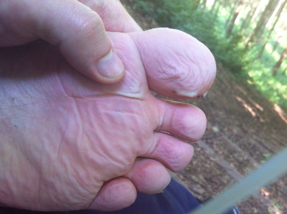 I know this is nothing compared with other runners feet pics I have seen lol. This has now become a top priority for me to master, not only to deal with blisters (I’ll use my Fixing Your Feet book), but also how to keep them dry. I have T184 mile Endurance Race in 2016 and I know that the grass will be wet in the mornings along the River Thames. It was enough to knock my morale and make me stop my journey.


As I walked up hills in the forest there was a big drop to the right of me and I didn’t see the drop but I saw a lake and kept hallucinating. I kept thinking how I’d like to take a dip in the lake but it wasn’t really there and the picture eventually became clear and all I saw was a the big dip that was really there.

Here I am looking exhausted and feeling it. I was sat on one of those wooden cross over fence things. It felt so nice to have something to sit on and get my feet off the ground.
At about mile 8 of today I remember just starting to cry. I kept slogging along at like 3mph. I kept thinking about how I wanted to just lay down on the ground and sleep. Even just for an hour. I realised that 3 hours sleep after 40 miles isn’t enough to sustain another 34 miles the next day. I wanted today to be the last day and reach the end. At mile 12 I kept losing the way marks and getting lost. I felt disorientated and realised I was walking around in circles.

I only continued another 5 ish miles and then I decided to come off the trail and head to a local pub to eat and call for a taxi home. I was 15 miles away from finishing my planned journey. Although when I got home and calculated the distance I thought it would be 89 miles and it was 89.9 for what I did. So I had actually done more than expected. This stands to reason as I got lost on a few occasions.
I had told myself that it comes to a certain point that when you believe you have found what you where looking for there’s no real need to keep looking. I had learned so much for future events and adventures that it was now time to go home and analyse all the information that I had absorbed from this experience.
I want to thank my husband who helped me along the way with the odd text of support from him. Also I want to thank everyone on my Facebook friends. I made a post to ask for their support as I was feeling it emotionally at the end of day 2. I had so many replies. I was absolutely gob smacked. Thank you so much for your support it meant the world to me and still does. You made me cry… just a little 😉 Xoxo
My hat goes off to those out there running 100 milers and more. I can’t wait to get to that point. I have had little training due to injuries lately. I’m seriously looking forward to getting some proper training behind my belt for some ultra events and some more fast packing.
Who knows that’s next? I am now tapering for the Birmingham Black Country Half marathon on July 4th. As I write this it’s only a day since I got home and I’m feeling much better already and hope to be back out running as normal tomorrow.
I have the JW ultra coming up in September it’s 30 miles on the canal from Stratford Upon Avon to Birmingham. My friend has offered for my to come and practice the route with him soon. I think we are going to after we have done the Summer Round the Reservoir Marathon on 26th July in Northampton.

June 21st, 2015 at 11:01
Hey Scotty 🙂 it was great to meet you in longley green! I was so surprised to see another vegan here, just had to say hello 🙂
Sounds like you had an awesome trip, you’re doing a great job of showing how fit and healthy vegans can be!
LikeLiked by 1 person
June 28th, 2015 at 14:01
Good work Scott!! How far is it to Worcester from the canals by Wast Hills? I live in Stirchley so it is only about an extra 5km from there and was thinking of running it with my back pack sometime in late July early August when the weather is good and I have no more races on the horizon for a few months
LikeLike
June 28th, 2015 at 18:13
Not far about 22 miles into the centre. It’s mostly down hill so it’s a nice run. There are a few sections above the canal though. I’d be happy to show you the route sometime if you wanted as I have done it from Bham to Worcester 7 times now. Alternatively here’s the route.
https://connect.garmin.com/modern/activity/649083975
Cheers.
LikeLike
July 29th, 2015 at 13:32
[…] recently on my 4:05:03 marathon. I also used this method when I fast-packed (ran and walked) 90 miles in 50 hours including sleep time. On day two my feet were so sore. I had hardly ran much and at about mile 20 I […]
LikeLike